
Veracruz, Mexico was struck by a 6.5 Mw earthquake this morning, at approximately 7:11 am. Here is the earthquake summary report from the US Geographical Survey:
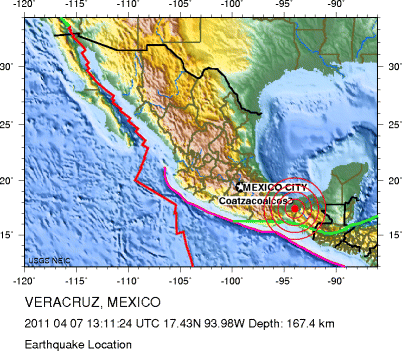
Region: VERACRUZ, MEXICO
Geographic coordinates: 17.431N, 93.978W
Magnitude: 6.5 Mw
Depth: 167 km
Universal Time (UTC): 7 Apr 2011 13:11:24
Time near the Epicenter: 7 Apr 2011 08:11:24
Local standard time in your area: 7 Apr 2011 04:11:24

Location with respect to nearby cities:
57 km (35 miles) S (169 degrees) of Las Choapas, Veracruz, Mexico
79 km (49 miles) SSE (168 degrees) of Agua Dulce, Veracruz, Mexico
79 km (49 miles) SW (234 degrees) of Huimanguillo, Tabasco, Mexico
84 km (52 miles) SE (137 degrees) of Minatitl�n, Veracruz, Mexico
483 km (300 miles) NW (311 degrees) of GUATEMALA CITY, Guatemala

The city of Veracruz is a major port city and municipality on the Gulf of Mexico in the Mexican state of Veracruz. The city is located in the central part of the state. It is located 90 km (56 mi) along Federal Highway 140 from the state capital Xalapa, and is the state’s most populous city. Veracruz is Mexico’s oldest and largest port and the port most connected with its history. Click here for more information about Veracruz.
In related news, northeast Japan was struck again this morning by a powerful earthquake, measuring 7.4 Mw. Click here for more information. No tsunami alert has been issued.